
Why Rivers Need Forests
Riparian corridors are where the wild things are.
By Wendee Holtcamp
A version of this story was originally published in Texas Parks & Wildlife Magazine, Dec. 2001.
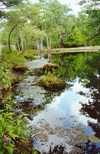
Natural drought and flood cycles create rich soils and lush habitats in the region surrounding a river and its tributaries. These streamside strips, often forested, are known as riparian corridors. Waterfowl, songbirds, frogs and toads, mammals, and even fish use this region where land meets water. Riparian corridors have higher numbers of wildlife and a greater species diversity per acre than in any other habitat type.
As Texas' population continues to grow, riparian forest is disappearing due to urban sprawl, reservoir construction, and a recent increase in demand for hardwood timber. Over 60 percent of riparian corridors have been destroyed. Particularly in the eastern half of the state, many of these riparian corridors are bottomland hardwood forests, the most rapidly disappearing wetlands type in Texas. "Bottomland hardwood forests are threatened throughout Texas, even more so than coastal prairie," says TPW Upper Coast biologist Woody Woodrow.
How does the loss of riparian corridors affect the health of our streams? That was a question addressed by U. S Geological Survey biologist J. Bruce Moring in a recent study of the San Jacinto River Basin, which encompasses the Houston/Galveston region.
Moring analyzed small to mid-sized streams in land uses ranging from national forestland to urban development. He compared stream channel structure, extent of upstream forest, riparian corridor vegetation, adjacent land use, and biodiversity of bottom-dwelling macroinvertebrates - mostly aquatic insects. Because of their sensitivity to water pollution, these invertebrates serve as biological indicators of stream health.
"I found a positive correlation between the biointegrity of the stream reach, and the proportion of the upstream drainage that was forested," explains Moring. "In addition, I found a negative correlation between the number of people per square mile and biointegrity."
The seven healthiest stream reaches -- including Big Creek in Sam Houston National Forest, Luce Bayou near Huffman, Caney Creek near Willis, and the East Fork of the San Jacinto -- all lie within in the highly forested northeastern part of the river basin, an area that is currently undergoing rapid population growth. "Given that development is inevitable in these areas, the implication is that the state work hard to establish [corridors]," says Moring. "We should minimize amount of deforestation that takes place, but at the very least maintain these riparian corridors in some meaningful way."
While Texas legislators and community leaders diligently plan ways to ensure adequate water supplies for Texans over the next half-decade, more decision-makers are realizing that healthy, flowing rivers for wildlife also mean clean water for people. "All these biological benefits that we get from riparian corridors are important," says Woodrow, "but one of the most important benefits is that these corridors are essentially for people. They should be conserved for the water quality needs of the people."
Text Copyright © 2000 Wendee Holtcamp
Photos Copyright © 2000 Matt & Wendee Holtcamp
~**~**~**~**~
www.wendeeholtcamp.com
Copyright © 2005 Wendee Holtcamp